Canal walk 4 – The Ocean to Stroud

When the canal is navigable all the way back to Saul Junction, there will be significant canal traffic and the bridges as well as the locks will need to be used fairly frequently.

< Previous | Index | Next >

In this fourth section of the canal walk, we continue along Stroudwater Navigation. Although the canal is in working condition along most of this section it is not yet connected to any other navigable waterway except for part of the Thames and Severn Canal that we’ll cover later.

This walk is 5.0 km (3.1 miles)

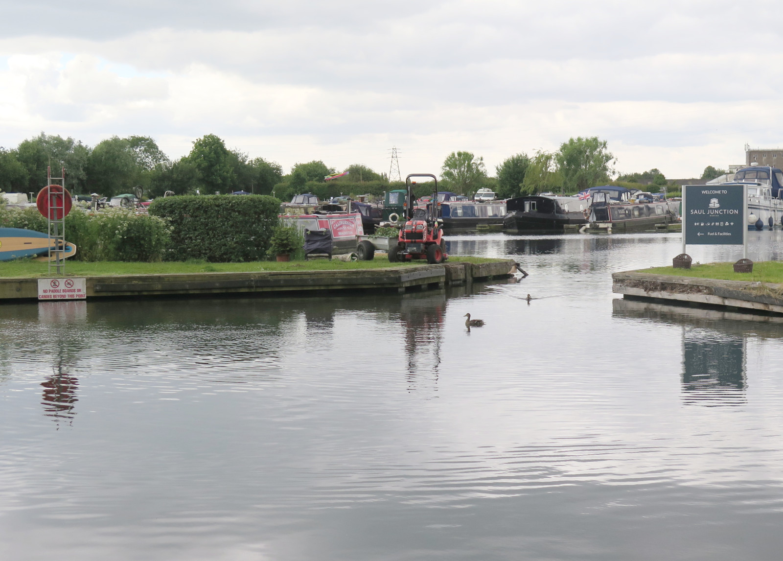
In the previous article we passed under the new Jubilee Railway Bridge and reached The Ocean. (Hint: Click the map icons for larger, draggable and scalable versions. Click the photos for full size, too.)

From the The Ocean to Stonehouse Bridge

This section is 1.3 km (0.8 miles)

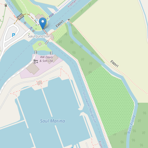
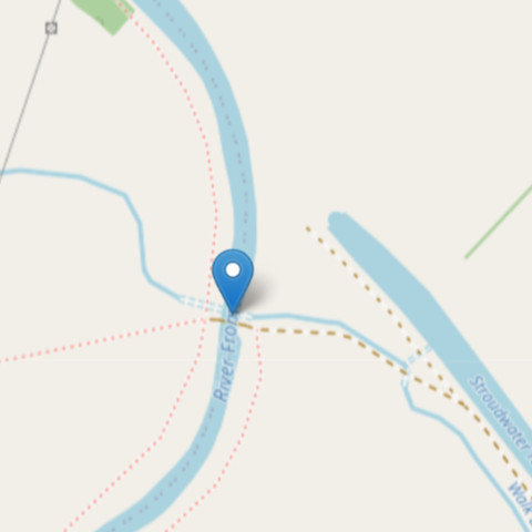
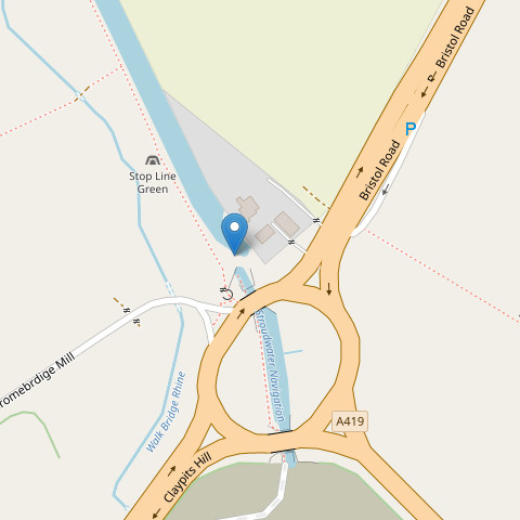
The map marker points to The Ocean at the end point of the previous walk. You can access the towpath from the A419 via Court Farm Mews, but if you arrive by car I suggest parking on Boakes Drive or one of the roads connected to it. You can walk past St Cyr’s church to the canal, and cross the Ocean swing bridge to reach the towpath. All of this will be clear if you expand the map.

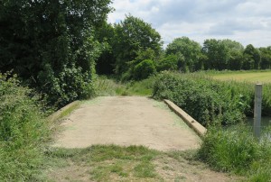
While you’re in this area you might like to walk through the nature conservation area. There are good views of the canal from Nutshell Bridge as well, accessible by footpath from the towpath (more on that shortly) or from the churchyard. When you are ready, walk east along the towpath, leaving The Ocean behind and passing under Nutshell Bridge.

Looking back to Nutshell Bridge

There is no direct access to the bridge from the towpath, but about 60 m beyond the bridge, look for a narrow footpath leading away from the canal. If you want to access the bridge from here, take this footpath, turn right onto a similar path at the four-way crossing, then right again to cross the bridge. Retrace your steps to return to the towpath. Next you’ll pass Boakes Drive (photo below) where modern, brick-built homes have enhanced surroundings provided by the canal, you might even see boats in the canal at this point, although currently they can only travel moderate distances.

Boats on the canal at Boakes Drive

A little further on again you pass under Stonehouse Bridge with its murals. This modern bridge carries the Stonehouse to Leonard Stanley, Dursley and Nailsworth road. It was built by Gloucestershire County County in 1999.

Stonehouse to Ebley Mill

This section is 2.0 km (1.2 miles)

Ryeford Bridge and a canal workboat

After one further bridge and some woodland on the left bank, look out for ‘Skew Bridge’. This is an old iron Midland Railway bridge that crosses over the canal at an angle (hence ‘skew’). The railway was closed in 1966 and now the bridge carries a cycle route. Immediately after Skew Bridge, the A419 passes over the canal, as does Ryford Road North, this time on a fine, slightly humped, stone bridge with a brick parapet (photo above). As you continue, look for the Ryeford footbridge with white, criss-cross pattern sides, and then you’ll pass under the black gantry of a pipeline bridge.

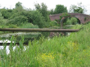
The next point of interest is a little further on; the Ryford double-lock with three lock gates was built to allow a greater rise in a short distance. Walking on from the double lock brings you to a part of the canal undergoing dredging (at the time of writing).

Dredging is an essential form of maintenance because canals typically get shallower over time due to a build up of silt on the bottom. Dredging when necessary restores the full depth of the canal allowing deeper draught vessels to use the canal.

In the event of active dredging, signs will re-route you to the towpath further along to avoid dangerous areas and allow the work to continue uninterrupted.

Passing under Oil Mills Bridge brings you to an attractive housing development with homes and gardens along the opposite bank. After the canal was opened, industry spread to this area (Ebley) from the Stroud direction, you’ll see plenty of evidence for this. The chimney of Ebley Mills is particularly impressive, and even the newer, residential blocks echo the shapes of the warehouses of the past. This is a good place for a coffee and a snack with pleasant indoor and outdoor seating. Cross the Ebley Wharf Bridge to the little square (expand the map, the pointer marks the bridge) and you’ll find Kitsch coffee-bar (K coffee-bar on the sign). Check it out on Trip Advisor or just take my word for it.

One other feature you might wonder about is the single lock gate across the canal, but there’s no lock! It’s part of an ingenious flood-prevention measure, diverting flood water to the River Frome whenever that becomes necessary.

Ebley Mill to Stroud

This section is 1.8 km (1.1 miles)

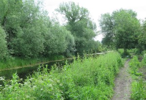
Now for the final section of this canal walk. Continue walking east from Ebley Mill along the towpath which takes you between the canal and the River Frome. You will pass Queen Elizabeth II Playing Field on your right, quite likely you’ll see the children’s play area with its ‘canal boat’. I walked over to take a look at this, it’s evidently inspired by Stroudwater Navigation and no doubt much enjoyed by younger children.

Ella’s boat and other murals

Hilly Orchard Footbridge is another, black, girder structure on brick piers; the towpath passes underneath. This is followed by Dudbridge Road Bridge carrying the A419; as you walk underneath this large, concrete bridge you’ll see a lot of fine murals painted by local schoolchildren, many of them showing refreshing, young humour at its best. One of my favourites is ‘Ella’s Boat’ making big waves washing over the sides of a bridge. It’s hard to work out which way the boat is moving, but it’s definitely travelling much too fast for the Stroudwater Navigation!

Chestnut Lane Bridge

After the A419 bridge and its memorable artwork you will reach Dudbridge Lock and then Foundry Lock. This pair of locks needs further repair after initial restoration some time ago. Several other things are going on here, there’s a turbine generating electricity between the two locks as well as a water discharge to Ruscombe Brook and two weirs. Continuing the walk you will pass Chestnut Lane Bridge and then Lodgemore Lane Bridge, many of the opening bridges can be operated by anyone holding the correct key. With the canal in its present state the bridges rarely need to be opened, but in a few year’s time, when the canal is navigable all the way back to Saul Junction, there will be significant canal traffic and the bridges as well as the locks will need to be used fairly frequently. This will bring new challenges with water supply and traffic management.

As you return to a more industrial area, you will pass through an opening in a dressed-stone wall. As you do so, look carefully at the stonework on the left side of this entrance. The deep, horizontal grooves in the stone were caused by the rubbing of barge tow ropes over many years of use. They are a visible relic of the passing of countless barges, bargees, horses and ropes over a couple of centuries!

Thames and Severn shake hands

Just a short distance more and you will come to a monument by the towpath (open the map below, the marker points to the monument). This is the end of the Stroudwater Navigation. We are now in Stroud where coal from South Wales and the Forest of Dean would have been brought by barge from the north and west bank of the River Severn for use in Stroud’s many spinning and cloth weaving mills. Traditionally these had been water powered, but the arrival of steam power required coal, and this could be obtained more cheaply than before once the canal had been built with some of the cost savings providing profit for the canal owners and barge operators.

The Thames and Severn Canal was constructed to continue the waterway further east to make it possible to take goods from Stroud to Lechlade on the River Thames. It opened in 1789, ten years after the Stroudwater Navigation. The next part in this series will continue eastwards from the shaking hands monument as we explore the Thames and Severn Canal.

Canal walk 4 is complete, so thanks for coming along.

See also:

*This is a great source of canal images, history and all sorts of detail. Highly recommended and well worth exploring!

< Previous | Index | Next >

Useful? Interesting?

If you enjoyed this or found it useful, please like, comment, and share below. (If you don’t see those links, click the article’s title above the main photo and they will appear.) Send a link to friends who might enjoy the article or benefit from it – Thanks! My material is free to reuse (see conditions), but a coffee is always welcome and encourages me to write more often!

Canal walk 3 – A38 to The Ocean

Standing on the bridge and looking left you will see the course of the new section and work ongoing in preparation for excavating the channel.

< Previous | Index | Next >

Heading further south-east from the A38 roundabout we cover the ‘Missing Mile’ and then reach a section under heavy repair, and finally a section that is actually navigable. Read about it in this third article.

In the previous article we reached the short, new section of canal inside the A38 roundabout. (Hint: Click the map icons for larger, draggable and scalable versions. Click the photos for full size, too.)

From the A38 to the M5

This time. we begin from the gate between the field and the centre of the roundabout; the map marker points to your initial position on the roundabout. Facing the roundabout, turn right and cross the exit and entrance of Fromebridge Mill, then follow the footpath along the right-hand carriageway of the A38. This is not a pleasant walk, but fortunately it’s not long.

Look out for the point where the road crosses the river, and 50 m beyond that you need to cross both carriageways (with great care, one carriageway at a time, the traffic can be fast). Find the footpath through the gate on the other side of the road. The map marker points to the path and the photo below will help you identify the gate you need.

Start of the path along the Frome

This footpath runs along the south-east bank of the River Frome and gradually approaches the M5 motorway which you’ll soon see and hear ahead of you. If you spot any markers for the Thames and Severn Way you can safely follow them for now.

The Stroudwater Navigation canal is filled in at this point and was some distance beyond the river but running roughly parallel. This is part of the section called the ‘Missing Mile’, the remainder of it is the other side of the M5. The river runs under the motorway, while the footpath passes through a tunnel alongside the river. Sometimes water and mud collects just inside the tunnel entrance; hopefully your footwear will be up to the task of passing this point and you’ll emerge on the eastern side of the M5.

Taking the canal under the M5

You’ve just walked beneath the M5, but how will the canal manage it? The original canal passed some distance north-east of the footpath tunnel and it would very expensive indeed to build a new route under the motorway. However, the River Frome passes under the M5 and it was decided that the best solution is to divert the canal from its old route and share the channel used by the river. A barrier will be built under the road to separate the river and canal from one another.

The Missing Mile will need to be re-dug, but along a slightly different route to take the canal from the A38 roundabout to the M5 crossing, and then joining up with the remaining canal by another new section returning to its original route again.

The gravelled track

Meanwhile our walk takes us along the river bank until we reach a road called Springhill in the village of Churchend. Turn left on to the road and in a short distance, take the gravelled track on the left (see photo).

At the far end of the short track you will come out near to a brick bridge. This is Westfield Bridge, part of the original canal and it marks the other end of the missing mile.

The map marker is centred on the middle of the bridge. Standing on the bridge and looking left you will see the course of the new section and work ongoing in preparation for excavating the channel. Looking right you will will see restoration under way on the original canal as it continues eastwards. The brickwork for Westfield Lock (aka John Robinson Lock) is under reconstruction right by the bridge (photo below). The Missing Mile is all behind you now!

Westfield Lock

At the bridge, look for any temporary signs for the towpath (a public footpath at this point). The path might be before or after crossing the bridge; if possible, you need to turn right (east) from the bridge along the canal. Note: if the footpath is closed because of the ongoing work, the alternative is to return down the track back to the road and turn left up the hill to Pike Bridge. But assuming the footpath is open, along the way you’ll see a lot of work ongoing to restore the old canal to a working state. Several locks are being actively worked on. The footpath takes you up to Pike Bride where you can look back to get an excellent view of the ongoing work. Cross the bridge and you’ll see the continuing canal in water and in good condition.

Onward to The Ocean

Follow the towpath east from Pike Bridge, after passing Pike Lock on your right, the first thing to note is the riveted, iron narrowboat ‘Leviathan’, used until the 1990s as a workboat by restoration volunteers. Another 150 m brings you to Blunder Lock, very close to the A419 road and the second in a ladder of locks – Pike, Blunder and Newtown. Blunder Lock probably got its name because it was dug to the wrong depth by the engineer, despite clear and detailed instructions.

Bond’s Mill

Another 90 m brings us to Newtown Lock and we start to get away from the A419; the tow path takes us through an idyllic, wooded area with a peaceful canal full of water as it would have been as a working waterway. Bond’s Mill is the next landmark and the unusual two-storey World War II pillbox is notable. It’s worth stopping for a while if you have time. Sometimes the pill box is open, but if not there are useful information boards on the outside.

Ocean Jubillee Bridge

Soon after Bond’s Mill comes a major achievement, the Ocean Jubilee Bridge. The canal was here before the railway, of course, and when the railway was built, they simply constructed a bridge to cross the canal, just as they would to cross a river or a road. The canal went out of use, largely due to competition from the much faster and more efficient railways; over time the bridge needed replacement. When the time came to do this, the railway engineers decided that a culvert would suffice, with the embankment extended over it. This left the disused canal in a state where it could not be restored without building a new bridge. Network Rail engineers did exactly that, and the result is what you see today.

And, finally for this part of our canal journey, walk under the bridge and take a look at the widening of the canal at this point. This body of water, a haven for wildlife of all kinds, has been known for a very long time as ‘The Ocean’. Nobody knows for sure how or why it acquired that name, but it might have been the largest body of open water known to the local people.

That’s it for Canal walk 3, thanks for travelling with me.

See also:

*This is a great source of canal images, history and all sorts of detail. Highly recommended and well worth exploring!

< Previous | Index | Next >

Useful? Interesting?

If you enjoyed this or found it useful, please like, comment, and share below. (If you don’t see those links, click the article’s title above the main photo and they will appear.) Send a link to friends who might enjoy the article or benefit from it – Thanks! My material is free to reuse (see conditions), but a coffee is always welcome and encourages me to write more often!

Canal walk 2 – Saul Junction to the A38

There was an aqueduct close to this point where the canal crossed over the river

< Previous | Index | Next >

Heading further south-east from Saul Junction there are several little pieces in good shape, and a lot of repair work ongoing. You can read all about that work right here in this second article.

Saul Junction
Saul Junction Marina

As mentioned in the previous article, the Stroudwater Navigation continues straight across the much larger Gloucester and Sharpness Canal. Looking south-east across the ship canal you can clearly see Stroudwater Navigation continuing, not only full of water, but still in use. We’ll cross the footbridge and follow it from that point. (Hint: Click the map icons for larger, draggable and scalable versions. Click the photos for full size, too.)

Walking south-east across the footbridge (see pointer on map) there is a right-hand bend and then an opening from the canal to a thriving marina.

The canal itself is very wide at this point and there are many moored boats alongside the towpath, The photo shows the widened Stroudwater Navigation in the foreground and the marina entrance. From here, the towpath continues to Walk Bridge.

Originally built as a swing bridge, Walk Bridge was replaced by a concrete and brick constuction, so a new opening bridge must be constructed to replace it. Cross the road and it’s clear that the canal is still in water at this point, but there’s no towpath. Enter the field by the stile, turn left, and walk diagonally across the field to the far side leaving the canal behind and to your right.

This brings us to Whitminster Bridge and Lock where there’s another glimpse of the canal’s remains. The photo below shows the point marked on the map. Turning a couple of metres right along the farm track will give you a view of the old canal lock. There was another swing bridge at this point.

Easy to go wrong here!

The small footpath to the left in the photo is part of the towpath and this is the route to take next. As you follow this path you’ll see the River Frome on your left. The canal has been filled in and would have been on the right.

The path and the river both bend to the right and then the path enters a strip of woodland along the river bank.

Through the wood

The path is poor, with large potholes filled with mud after prolonged rain. Care is needed and there are many roots that form real trip hazards, but the woodland doesn’t continue for very long (250 m or so) so slow and careful won’t reduce progress very much overall.

Once again, the river and footpath bend to the right, look for a concrete farm bridge (photo) across the river and take it, you’ll soon have the canal on your right. There was an aqueduct close to this point where the canal crossed over the river, but it no longer exists and the canal has been filled in for a short distance.

The map marker points to the bridge mentioned above; if you expand the map you can see the end of the woodland at top left and the canal section in water as well as the filled in part.

That looks more like a canal now!

The next major feature is a crossroads of tracks and footpaths, there’s a post here with a blue Cotswold Canals sign which you should follow. The canal is in water again at this point, stand on the track where it crosses the canal and you can see it for a long way in both directions. you’ll also have a clear view of the canal as you continue along the towpath (photo). At the time of writing dredging work is underway on some days. If you’re unlucky parts of the towpath will be closed and you’ll be redirected. But most likely it will be open (and is always open at weekends and on summer evenings).

On to the bridge and pillbox

The final section of this walk is quite straightforward – just keep following the towpath. There are some interesting things along the way though, and an unexpected treat at the end as well. On your way you may see evidence of the dredging work still active along this section.

When you come to a stile, cross it into the next field and continue on the towpath. A little further and you’ll notice a large pipe acros the canal and just beyond it a brick-built bridge, this is ‘Occupation Bridge’. The pipeline was constructed during World War II, part of a network to carry aviation fuel for the RAF. It is still in use and will need to be diverted beneath the canal.

Beyond the bridge you’ll find a pillbox (also WW II) near the right bank of the waterway, and shortly afterwards you’ll arrive at the destination for this article, the A38 roundabout. Here comes the unexpected treat I mentioned earlier. Make your way through the galvanised steel gate and turn left, a short downhill scramble. Here you can pick up the towpath again and explore a newly built section of canal crossing the centre of the roundabout. So astonishing to see a newly built canal in the middle of a major intersection!

The canal here was built by National Highways who also constructed the roundabout. When you reach the far side you’ll see that the canal currently ends at this point. The ‘Missing Mile’ begins here and we’ll explore it in the next article, ‘Canal Walk 3’.

See also:

*This is a great source of canal images, history and all sorts of detail. Highly recommended and well worth exploring!

< Previous | Index | Next >

Useful? Interesting?

If you enjoyed this or found it useful, please like, comment, and share below. (If you don’t see those links, click the article’s title above the main photo and they will appear.) Send a link to friends who might enjoy the article or benefit from it – Thanks! My material is free to reuse (see conditions), but a coffee is always welcome and encourages me to write more often!

Canal walk 1 – Severn to Saul Junction

Severn trows were flat-bottomed, single masted sailing vessels, and the Stroudwater canal was wide and deep enough to take them.

< Previous | Index | Next >

This section of Stroudwater Navigation is not being restored, but it is certainly of historical interest and mostly remains visible on the ground. It’s still possible to walk almost all of the towpath and not too hard to imagine what it might have been like when it was in use.

The connection to the River Severn
The River Severn at Framilode (near high tide)

The physical point where the canal joined the Severn is not accessible as it’s on private land. However, it’s easy to get very close. The River Severn is still tidal at this point, and the canal engineers had to take this into account. Instead of a single lock gate providing access, there were several; this allowed boats to transfer between river and canal for longer periods as the tide ebbed and flowed.

To find this spot on the ground, visit the village of Upper Framilode and look for the point near Lock House where the road crosses the line of the canal, then click the tiny map on the right for a larger, draggable and scalable version. The pointer shows where the canal and river meet, the place where Severn trows and other boats would have entered the canal heading towards Stroud, or exited into the Severn to make their way north towards Gloucester, Hereford and Worcester, or south towards Bristol and the River Wye to Chepstow and Monmouth. If you have time, pop into St Peter’s church in the village and enjoy the simple stained glass and the beautifully painted ceiling. A peaceful place, used by the local community in many interesting ways.

Severn trows were flat-bottomed, single masted sailing vessels, and Stroudwater Navigation was wide and deep enough to take them, with locks sized accordingly.

You can also view a map of the canal from the 1840s to compare with the current map. This, too, is draggable and scalable. If you open two browser windows side-by-side with the modern map in one and the historical map in the other, it’s fascinating to see the many changes that have taken place.

To start the walk south from Upper Framilode, look for the footpath just left of the canal as seen from Canal Row. This is the old towpath and runs between the canal and the row of buildings that grew up along the first 100 m of the canal. Presumably most, if not all, of these buildings sold necessities to the passing canal traffic. I can imagine everything from ale to fresh well water and hens eggs and other garden produce being traded while boats loaded and unloaded or just waited for a lock to fill or empty.

Heading south
View back to Canal Row – from left are the canal, grassy towpath, and row of buildings

The first landmark you will come across is ‘The Ship’ inn. You’ll pass the pub and then its car park, both on the left. After passing it, looking back you’ll see its name painted on the building’s wall. It’s only 250 m or so from the start of the walk.

It’s not hard to imagine the trows travelling to and fro along this section of the canal. No doubt the pub was a popular stop.

The Ship Inn, looking back towards the start

As you can see, this first section of canal is still in water, and along the way you will have noticed the large stones edging the canal. Lock gates and other wooden structures have long since gone, of course, rotted away by the action of rain, fungi and bacteria. Like all human technology, canals must be maintained if they are to continue working. Although there’s still water at this point the canal is certain to be heavily sited up, and reeds, rushes and other water-tolerant and water-dependent plants have colonised very effectively.

Saul Bridge

The map marks the next point on the journey, the place where Moor Street crosses the canal over Saul Bridge. It’s the first bridge you come to and is not far beyond The Ship Inn. Originally this was a swing bridge, but the modern replacement is concrete and brick. Continue along the towpath beyond the bridge and you quickly come to the end of the section of canal remaining in water. The scene changes quite a bit from here on.

The River Frome comes alongside the tow path on the left at a point where the canal (still on the right) becomes dry; you can see this point on the map in the previous section. Don’t be confused! For a while you will see the Frome on the left of the tow path and the dry canal on the right. In places the canal has been filled in and that makes things even more difficult to visualise. Sometimes you can spot the left bank of the canal as a curved ridge, even when it runs through an open, grassy field. The towpath would probably have run along the flat top of this ridge.

River, footpath, and the bank of the canal

Just keep walking on the footpath and you’ll be OK. If you see signs for the Thames and Severn Way, Cotswold Canals Trust, or Saul Junction follow them; they will all guide you along this section of the canal. After the section of infilled canal, there’s a very overgrown part, and finally the footpath opens onto Saul Junction itself.

Here, the Stroudwater Navigation (opened in 1779) continues straight across the much larger Gloucester and Sharpness Canal, which opened in 1827, carries much larger vessels, and connects Gloucester Docks with Sharpness. At Sharpness, vessels can continue on the river to and beyond Bristol. Look across the ship canal where you will see Stroudwater Navigation continuing, not only full of water, but still in use. I’ll write about that next section in a future article.

Once the ship canal was open, it made a much better, non-tidal route to Gloucester or Bristol, and that’s why this section of the Stroudwater Navigation languished and fell out of use. The crews of trows coming and going to Stroud simply had no reason to enter the Severn from Saul Junction after 1827.

See also:

< Previous | Index | Next >

*This is a great source of canal images, history and all sorts of detail. Highly recommended and well worth exploring!

Useful? Interesting?

If you enjoyed this or found it useful, please like, comment, and share below. (If you don’t see those links, click the article’s title above the main photo and they will appear.) Send a link to friends who might enjoy the article or benefit from it – Thanks! My material is free to reuse (see conditions), but a coffee is always welcome and encourages me to write more often!

Another message from Yara

Sometimes the worst things are done when the perpetrators are most afraid; and right now I think Putin is very much afraid.

This is a message of despair from a brave Ukrainian lady who deserves so much better. All Ukrainians deserve so much better. Yet I know the despair will be temporary.

A photo from Yara’s message

Yara has an irrepressible nature and despite the terrible circumstances I know she will regain a measure of hope and want to share Ukrainian culture and art with her readers again quite soon.

Please do read her message for today. Below I’ve copied a reply to it that I posted there a few minutes ago. I think there is growing cause for hope, and that’s what I wrote about and want to emphasise.

But before I share that reply: What can you do to help? Visit Yara’s site and take a good look around, read some of her other, more upbeat, messages. Consider becoming a supporting member, buy her a coffee, leave her a reply to one or more of her posts. Contact your government representative asking them to do more. In the UK write to your MP. Hint: Write again after our upcoming elections, you might find you have a different MP.

My reply

Wanting better for you, Yara. Wanting better for Kharkiv. Wanting better for every part of Ukraine.

Sometimes the worst things are done when the perpetrators are most afraid; and right now I think Putin is very much afraid.

Everything in Russia is beginning to fall apart – in fact, more than ‘beginning’. The evidence is everywhere.

  • There is a big shake up in the Russian Army, many senior officers are being arrested, perhaps because Putin fears a coup. Shaking things up does not make an army more effective. Just the opposite.
  • Inflation is ‘under control’ according to Putin. He is ignoring something like 8% inflation per month. How long can he pretend?
  • Crime rates are spiralling out of control.
  • Buildings are collapsing (not bombed, just badly built and lacking maintenance).
  • Roads and railways are broken, water supplies are broken, power supplies are broken, Ukraine is destroying oil refineries. Nothing is being repaired because so many skilled people either left Russia, or have been sent to die in Ukraine.
  • Nearly half the Black Sea Fleet is on holiday, resting peacefully on the sea bed.
  • Aircraft, air defence, airfields are being destroyed daily.
  • The war is going badly, very badly in fact.

What will happen next?

Putin’s time is probably short now, everything is going wrong for him.

Ukraine’s nightmare might end very suddenly, though nobody knows when. It could be in a year’s time, or just a month, or a week, or it might be tomorrow.

None of this affects how you feel right now, so you (like so many in Ukraine) will have to suffer longer. But feelings change day by day, One day, hope will grow like a tree in the springtime. Hope will blossom and flourish. But perhaps not today.

I know you, like all Ukrainians, will cling to hope until it’s no longer needed. Then you will all be able to sing, and dance, and have parties in the street, and then start on the huge task of rebuilding your shattered lives and towns and cities.

Slava Ukraini! Heroyam slava! 🇺🇦 🇺🇦 🇺🇦 🇺🇦 🇺🇦

War, survival, victory

Nobody asks your permission or opinion, and suddenly people and places you love are injured and damaged by bombs and missiles.

Today I want to bring you news from Ukraine. I’m going to do this by giving you a glimpse through the eyes of Yaroslava Antipina who lives in Kyiv; if you want to know about a topic, the best sources always include local people.

The image above shows one of Yara’s pages on the web, here (and elsewhere) she writes regularly to inform her readers about the war, but also about Ukraine and Ukrainians. She shows us the architecture, the places she visits, the art galleries and museums and cathedrals and much, much more. Like all Ukrainians, and like my parent’s generation in the UK, Yara knows what it’s like to be thrust unwillingly into armed conflict. Nobody asks your permission or opinion, and suddenly people and places you love are injured and damaged by bombs and missiles.

But that’s enough from me today. I’m simply going to re-post Yara’s latest Sunday message to her followers. I recommend and urge you to read more of her material, you can find her in various places.

–oOo–

Hi!

I am writing to you from sunny Kyiv. The weather is mild and gentle, and on such days, it is hard to believe that the war is walking heavily somewhere on our land.

The situation in Kyiv is not so bad compared to frontline or near frontline territories. If you come here, you will see a city that tries hard to live. And you even feel this tension, this strong desire to show everyone, especially the enemy, that we are alive and our spirit is strong.

I have just got this thought…

Do you also feel that my letters are like conversations between two people? I hope so.

Okay, in this letter, you will see photos of Ukrainian artists from the so-called Samarkand era. Samarkand is a city in Uzbekistan. From 1941 to 1944, this city became a home for many Ukrainian artists. I will briefly tell you about this era a bit later in the letter. And the photos are from the exhibition I visited this week.

Petro Sulymenko (1914-1996), Sher-Dor, 1942

Some explanation: Sher-Dor Madrasa is a 17th-century madrasa (Islamic school) in the historical centre of Samarkand.

Let’s talk about the war. I rarely tell you about the situation on the frontline. It is a topic better explained by war experts or military personnel. But this week, I heard and read a lot about it, especially Chasiv Yar, so I decided to figure out why Chasiv Yar is so important for the russians.

So, Chasiv Yar is a city in Donetsk Oblast. About 13,000 people lived here, but as of early April, about 700 remained. It is the highest point for hundreds of kilometres around. The city stands on hills that protect it from the east and south like defensive walls.

Chasiv Yar is the ‘gateway’’ to the cities of Kostiantynivka (7 km to the west) and Kramatorsk (25 km to the northwest). If the russian forces manage to capture Chasiv Yar, they will have the opportunity to launch an offensive on them and other settlements of Donetsk Oblast, which still are controlled by Ukraine. You can read a short review in Politico or a detailed explanation of the importance of Chasiv Yar in The New York Times.

Oleksandr Syrotenko (1897-1975), Evening. Samarkand, 1943

I want to add a few lines about the situation in Chasiv Yar now. Of the 700 people still living in the city, 80-85% are older people who refused to evacuate. Their main argument is that this is their home, and they want to stay here till the end.

Since February 2023, Chasiv Yar has had no gas and water supply, electricity, and poor mobile phone connection. Those who have stayed here rely on generators and water from wells to keep themselves alive.

All high-rise buildings in Chasiv Yar have been damaged by shelling; 80% of the damages are critical.

–oOo–

There are four more images of beautiful paintings and more informative text, but I want to encourage you to see those on Yara’s site… Thank you!

Attic staircase

Perspective changes how we see things generally … Whether you’re considering a person, or an opinion, or solving a practical problem, the way you look at things can change everything.

Donna and I visited William and Jane Morris’ home, Kelmscott Manor, in the little, Oxfordshire village of Kelmscott. They lived here from 1871 until 1896. It was a warm, sunny day and we enjoyed lunch in the garden as well as exploring the house.

The attic staircase

Kelmscott Manor is full of furniture from the Jacobean to Victorian periods, and of course it’s also full of William Morris designs in the form of wallpapers, fabrics, and tapestries. An amazing place and well worth a visit.

Yet something that stood out for me was this staircase connecting the attic space in the roof with the the lower floors of the house proper. What I like about the photo is the effect of light from the window, and the various textures: the sturdy, wrought iron handrail, which crosses oddly and uncompromisingly in front of the window; the wood of the stair treads; the polished timber of the railing at the top; the mix of reflected colours on what is actually a plain, white wall; and the odd angles created by variations in perspective – it’s quite magical!

Maybe I’ll post again about this lovely old house and its fabulous contents, but for now I’ll leave you with the interesting composition of light playing on an ordinary, day-to-day, attic staircase.

And there’s a life lesson here for us if we think a little deeper. Perspective changes how we see things generally, not just staircases. Whether you’re considering a person, or an opinion, or solving a practical problem, the way you look at things can change everything. Maybe you’re better at this than me, but I need to learn to alter my perspective more willingly when necessary.

See also:

A coffee is always welcome!

Everyone should see this

If you want to face down the playground bully you need more friends than he has, and preferably a larger, heavier stick to fight with.

Here’s a Times Radio interview of General Sir Richard Shirreff, sharing his thoughts on events in Ukraine, recorded on 9th April.

Times Radio interviews General Sir Richard Shirreff

Why do I think everyone should see it? Britain has done more to help Ukraine than many Western nations. So have Poland, France, Germany, Canada, the Baltic States, Finland, Norway and Sweden.

But we need to do so much more. If we do not, we are risking a future war between Russia and NATO. That, of course, is the last thing we want to happen, but if we don’t prepare for the worst case now, it may happen anyway, and partly (even largely) because of our lack of preparedness.

If you want to face down the playground bully you need more friends than he has, and preferably a larger, heavier stick to fight with. We have friends, but right now we are brandishing a twig and hoping the bully will turn away in fear.

He will not.

Sir Richard makes this very clear. That’s why we all need the chance to hear and evaluate what he has to say.

A coffee is always welcome!

Are we helping Ukraine enough?

The main thing that is necessary, and therefore the first thing to address, is to decide what outcome we want to see. How do we want this war to end?

Here in the democratic world, we claim to be helping Ukraine. But are we really doing enough? I think we began rather late, but after (and even before) the Russian invasion in February 2022 we did make some efforts to help Ukraine with arms and ammunition. And two final questions, ‘Why does it matter anyway?’ and ‘What more should we do?’

Beautiful Ukrainian scenery in Crimea (Wikimedia)

In thinking this through there are several things to be considered. Let’s deal with those briefly before discussing in more detail whether we are helping Ukraine enough.

The democratic world

We often hear people talk about ‘The West‘ as a catch-all term for the USA, Europe, and any other similar democracies around the globe. This would include the UK, Canada, Australia, New Zealand, Japan, South Korea and I could list more. ‘The democratic world’ is not the way we usually express it, but I think it’s a more accurate term than ‘The West’.

Ukraine

Most of us know where Ukraine is, particularly following the Russian invasion. Regular news coverage has given most people a reasonable level of knowledge about the place geographically, socially and historically. But we need to acknowledge that there are two distinct understandings of Ukraine. The democratic world accepts that Ukraine became an independent nation when the Soviet Union broke apart in 1991. Ukraine is also recognised by the UN and other international bodies, with borders widely accepted to include Crimea and the Donbas. But the current Russian leadership has a different view, claiming that Ukraine remains part of the Russian World and should be brought back into the fold, by force if necessary.

Countries that don’t identify as part of either the democratic world or the Russian world also view Ukraine in one of those two ways depending on the strength of their association with Russia. North Korea and Iran, for example, accept the Russian version. Many countries in South America, Africa, the Middle East, and Asia take the view of the democratic world, but by no means all. Voting at the UN reveals where the balance of opinion lies – and it’s not with Russia.

Helping Ukraine

Aid of various kinds has been provided to Ukraine. There has been financial support to the Ukrainian government to help with provision of public services and for reconstruction following Russian destruction of power supplies, hospitals, schools, industries and housing. At the same time a wide range of sanctions have been applied to Russian trade and we can see this as support for Ukraine as well.

Additionally there has been considerable help in the supply of weapons and ammunition to help Ukraine fend off Russian attacks; but this has come with strict limits (don’t use what we are giving you to strike targets inside Russia). Limiting the use of weapons in this way is effectively tying the Ukrainian armed force’s hands behind their backs. The argument is that the Democratic World does not want to ‘provoke’ Russia. That’s a serious weakness, not just for Ukraine, but for all of us.

And although European nations and their allies are still providing arms and ammunition, the USA is not, due to internal wrangling in the House of Representatives.

Is there more we should do?

Undoubtedly, yes, much more. The main thing that is necessary, and therefore the first thing to address, is to decide what outcome we want to see. How do we want this war to end? We should have decided this more than two years ago, even before Russian armour, aircraft, supply vehicles, and troops crossed the international border in a drive to Kyiv on 24th February 2022. There are only four possible answers here:

  • We want Russia to win
  • We want the war to drag on and on while Russia continues to commit war crimes, destroying towns and cities, targeting essential civilian infrastructure, and killing Ukrainian men, women and children
  • We want a ceasefire agreement
  • We want Ukraine to win, ie drive Russia back beyond the 1991 borders

So let’s consider the implications of each outcome.

We want Russia to win

This way lies madness, and I don’t think any democratic country is suggesting it. Even if we ignore the illegality of the war, and even if we ignore what Russia would do next (we can guess, given their actions in Bucha, Mariupol, Bakhmut, Avdiivka and so forth), we should never overlook Russia’s existing threats beyond Ukraine. Serious threats have been expressed towards Finland, the three Baltic States, even Poland; and who is to say it would stop there?

We want the war to drag on

In this case we would have to accept that we’d need to go on supporting Ukraine indefinitely with financial and military aid. That represents a very expensive choice! It would also seem to be an abhorrent and immoral choice as it would allow the civilian suffering to continue indefinitely. Does anyone seriously support such an option?

We want a ceasefire agreement

Ukraine would gain a respite from fighting, and so would Russia; it seems like a good choice that many people would support. But we need to think a bit harder about this option. First, it rewards the illegal hostility and land grab that has already taken place. A ceasefire would put an end to Ukrainian hopes of regaining its occupied territory, territory taken against international law and international recognition of borders. Are we really willing to let Russia benefit from its aggression?

And how long would such a ceasefire last? Russia has declared that it wants all of Ukraine (Reuters). Five or six years for Russia to regain its strength, build up its army and armaments, and what would then stop them from starting a new ‘special military operation’. Up until the day of the invasion in 2022, Russia had been telling the world it had no intention of attacking Ukraine! Putin is not a man of his word. Words mean nothing to him; he’s made that clear over and over again. He would simply ignore any commitments previously made in a ceasefire agreement. Trust him at your peril!

We want Ukraine to win

Considering the arguments above, this has to be a no-brainer. Why isn’t it? The answer is clear – we have not thought it through very thoroughly.

I want Ukraine to win, and I want all the countries that support Ukraine to want them to win too. And further, I want all those countries to let Russia know, in no uncertain terms, that our clearly declared intention is that they should lose this unprovoked, illegal war for which they alone carry the responsibility.

Why is it important that Russia understands this? Simply this, that Mr Putin respects strength and clearly expressed intentions. If he is in any doubt that we will settle for less than a full Russian withdrawal from Ukraine including from Crimea and Donbas, he will procrastinate and continue to fight. He may do that anyway, of course. But he must, if necessary, be forced to leave Ukraine.

Why does it matter anyway?

Russia is militarily weaker that they believed themselves to be two years ago, and Ukraine has proved to be far stronger than Putin expected. Russia will not give up voluntarily, so it’s essential that they are forced to do so. It is essential for Ukraine to win as soon as possible, to save innocent lives, to reduce the financial costs for Ukraine and her supporters, and to put Putin and Russia back into a place where they know they have lost and will be unwilling and unable to try again. It’s essential for peace and security in Eastern Europe, and very possibly in Western Europe too. We must not fail Ukraine and we must not fail ourselves. Democratic people deserve to live in a peaceful world. Autocracies must not, in the end, prevail. Indeed, all people deserve to live in a peaceful and harmonious world.

Please don’t misunderstand me, I would very much like peace and harmony with Russia. But that will not become possible until Russian forces withdraw from Ukraine, and accept that military conquest to extend Russian territory is not acceptable.

Historians remind us that we were in a similar situation in 1938 when Czechoslovakia was forced to give significant border areas to Germany ‘to prevent a wider war’. The disputed land was duly given to Germany, but German forces subsequently moved into the rest of the country and took control anyway. World War II broke out soon afterwards when German forces entered Poland.

And that’s what might happen now. Ukraine would be forced to give significant border areas to Russia ‘to prevent a wider war’. The disputed land would be duly given to Russia, but Russian forces would subsequently move into the rest of the country and take control anyway. World War 3 would break out soon afterwards when Russian forces enter Poland and/or the Baltic States.

Let’s not fall into that trap. We need to say, ‘No’, and say it very clearly indeed. We must not say, ‘OK, settle for part of what you want’. Because Putin will smile, take what we agree, and then take the rest later. And he won’t stop there.

There’s another thing to remember. We are not dealing with a reasonable person. Vladimir Putin has lied before, he has never been trustworthy, when he agrees to something it’s because it will bring him an advantage. He regards keeping his word as a serious weakness. He casually murders those who oppose him – even his friends. It’s hard to imagine permanent peace in Europe as long as Putin is alive and free. Russia cannot change while he is in charge. That, too, should remind us of the run up to World War II.

What more should we do?

We should immediately provide much more military support. France is working to provide more armour and air defence missiles. The United States must be deeply embarrassed at their present inability to provide ammunition and air defence help. Czechia has done really well to arrange to supply more than a million shells.

In parallel, our governments should urgently be ramping up manufacture of ammunition for our own stocks in addition to supplying Ukraine, and we must increase military budgets to innovate and enlarge our armed forces. Perhaps the war will not spread beyond Ukraine, but we cannot assume that. It is always better to be safe than sorry. We must stop acting as if war is far away and can never come closer. The old Boy Scouts motto applies – ‘Be prepared’.

See also:

Complete clarity on Ukraine

The Russian official line is certain to be rejected and disregarded by most governments, by NATO, by the UN, and by people of goodwill

Just take a look at Russia’s current demands for peace with Ukraine, expressed by Dmitry Medvedev. I’m sure you’ll agree that he puts it rather clearly; does this seem reasonable and fair to you?

How Russia treated Mariupol (Wikimedia)

The text below is an extract from today’s ISW report on the war in Ukraine. These are the Russian conditions for peace. It’s the official line, published by Dmitry Medvedev, currently Deputy Chairman of the Russian Security Council. This is what he calls a ‘peace formula’, it does have the merit of leaving us in no doubt about what Russia wants.

Medvedev begins the “peace plan” by rhetorically stripping Ukraine of its sovereignty, referring to it as a “former” country and placing the name Ukraine in quotation marks. Medvedev laid out the points of his “peace formula”, which he sardonically described as “calm”, “realistic”, “humane” and “soft.”

The demands are:

  • Ukraine’s recognition of its military defeat
  • Complete and unconditional Ukrainian surrender
  • Full “demilitarization”
  • Recognition by the entire international community of Ukraine’s “Nazi character”
  • The “denazification” of Ukraine’s government
  • A United Nations (UN) statement stripping Ukraine of its status as a sovereign state under international law
  • A declaration that any successor states to Ukraine will be forbidden to join any military alliances without Russian consent
  • The resignation of all Ukrainian authorities and immediate provisional parliamentary elections
  • Ukrainian reparations to be paid to Russia
  • Official recognition by the interim parliament to be elected following the resignation of Ukraine’s current government that all Ukrainian territory is part of Russia
  • The adoption of a “reunification” act bringing Ukrainian territory into the Russian Federation
  • The dissolution of the provisional parliament
  • UN acceptance of Ukraine’s “reunification” with Russia
Reformatted, extracted from the ISW report for 14th March 2024.

In a sense, this can be taken as a reply to the Pope’s recent statement about Ukraine ‘raising the white flag’. The Pope has since backtracked and clarified his statement, but Medvedev is most unlikely to backtrack his response.

The Russian official line is certain to be rejected and disregarded by most governments, by NATO, by the UN, and by people of goodwill throughout most of the globe. It is not acceptable as a starting point for negotiations of any kind, more a vain wish-list that very few can accept. Why, exactly, would Ukraine ‘recognise its military defeat’ when it is very clearly not defeated? And why does Medvedev think the entire world would ‘recognise’ that Ukraine has a ‘Nazi character’? Most of the world would be more likely to perceive such a character in the Russian government’s imperialist ambitions.

Dmitry Medvedev, and more to the point Vladimir Putin, seem to think they can get away with rewriting history, disregarding truth, invading an internationally recognised member state of the UN, breaking international law, and have the entire world let them get away with it. They are deluded. We will not and must not allow it.