Image of the day – 73

Of course, non-local companies are far, far better than empty shops. Cirencester has fewer empty shops than most towns; and we do have a good proportion of small, local businesses springing up all the time.

< Previous | Index | Next >

What’s in an image? Sometimes quite a lot, more than meets the eye.

I’m posting an image every two days (or as often as I can). A photo, an image from the internet, a diagram or a map. Whatever takes my fancy.

Click to enlarge

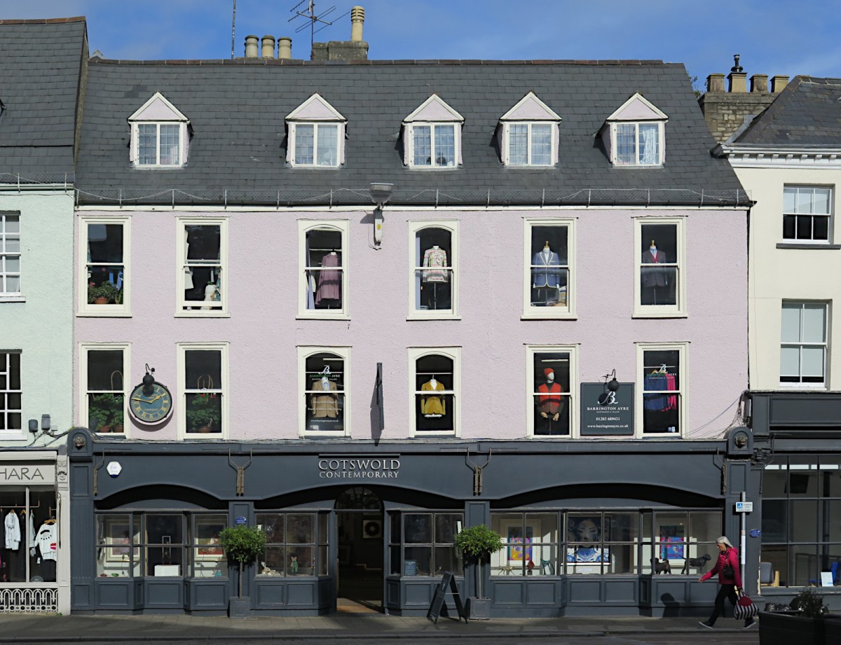
This shop was Stradlings when I was a child. It was a watch, clock and jewellery business and had been a clock maker at one time. If you enlarge the image you will see a clock between two first floor windows on the left. That clock is marked ‘Stradling maker Cirencester’, a relic and reminder of times past.

Businesses come and businesses go, that is normal, it has always happened. But something has changed dramatically in Cirencester as in towns across the county (and indeed much of the world). And it’s this – many of the incoming businesses are branches of large companies, often with little local knowledge or experience.

Of course, non-local companies are far, far better than empty shops. Cirencester has fewer empty shops than most towns; and we do have a good proportion of small, local businesses springing up all the time, especially restaurants, coffee shops and so forth. But the trend is clear, especially when you take the long view. I’m 76-years-old, but as a child almost every business seemed to be local. Perhaps the biggest exceptions were banks and building societies. Sometimes, it’s even in the names, ‘Nationwide’ is indeed a nation-wide building society!

But despite all this, many of the old names, like Stradlings, have left visible mark that can still be seen if you look closely enough. The old clock is still on the wall – a clock made in Cirencester! Not far from Cotswold Contemporary, the current owners of the clock, you’ll find an old sign above a shop front on the same side of the street. There are no words, just a black teapot and a cup and saucer. If you are ever in Cirencester Market Place, see if you can spot it, another emblem of the past. I won’t mention the current name of the shop, that would make it far too easy; but I will say that back in the day it was Anne’s Pantry. They sold little cakes, dainties and pastries to take away, or you could take a table inside for a cup of tea.

If you find the teapot or have memories of Cirencester to share, leave a comment.

Cirencester

For convenience, here’s a list of all the Cirencester area images:

A417 roadworks, Advent Market, Bishops Walk, Baunton, Canal 1, 2, Castle Street, Christmas lights 1, 2, Church 1, 2, 3, 4, 5, 6, Churn flood, Countryside, Fallen tree, Fleece, Gasworks, Gloucester Street, Hare 1, 2, Hospital, Market Place 1, Phoenix Fest, Riverside Walk, Stone plaque, Stratton Meadow, Tank traps, View, Wonky 1, 2, Yellow Iris

Themed image collections

The links below will take you to the first post in each collection

Cirencester, Favourites, Irish holiday 2024, Roman villa

< Previous | Index | Next >

Useful? Interesting?

If you enjoyed this or found it useful, please like, comment, and share below. My material is free to reuse (see conditions), but a coffee is always welcome!

Image of the day – 67

Because the church is so large (one of the largest in England), it’s sometimes called ‘The Cathedral of the Cotswolds’.

< Previous | Index | Next >

What’s in an image? Sometimes quite a lot, more than meets the eye.

I’m posting an image every two days (or as often as I can). A photo, an image from the internet, a diagram or a map. Whatever takes my fancy.

Click to enlarge

This is an interior view of Cirencester’s Parish Church of John Baptist. The long view you see here is the nave with the chancel at the far end (beyond the screen); the chancel is the oldest part of the building, perhaps dating to about 100 years after the Norman invasion; it’s in this area that the Saxon church stood. Alterations and additions were built at various times from the late 12th century through to the mid 16th century, the tower being added at the beginning of the 15th.

The church overlies parts of the Roman city of Corinium, possibly concealing some ‘missing features’. The city would have baths and a theatre as both were important features in Roman times. No trace of either has been found by the archaeologists.

Because the church is so large (one of the largest in England), it’s sometimes called ‘The Cathedral of the Cotswolds’. Nonetheless, it’s just a local parish church.

Cirencester

For convenience, here’s a list of all the Cirencester area images:

A417 roadworks, Advent Market, Bishops Walk, Baunton, Canal 1, 2, Castle Street, Christmas lights 1, 2, Church 1, 2, 3, 4, 5, 6, Churn flood, Countryside, Fallen tree, Fleece, Gasworks, Gloucester Street, Hare 1, 2, Hospital, Market Place 1, Phoenix Fest, Riverside Walk, Stone plaque, Stratton Meadow, Tank traps, View, Wonky 1, 2, Yellow Iris

Themed image collections

The links below will take you to the first post in each collection

Cirencester, Favourites, Irish holiday 2024, Roman villa

< Previous | Index | Next >

Useful? Interesting?

If you enjoyed this or found it useful, please like, comment, and share below. My material is free to reuse (see conditions), but a coffee is always welcome!

Image of the day – 66

The Parish Church was built beginning in the 12th century, near the site of an earlier Saxon church…It’s by far the largest building in the Market Place and dominates the space.

< Previous | Index | Next >

What’s in an image? Sometimes quite a lot, more than meets the eye.

I’m posting an image every two days (or as often as I can). A photo, an image from the internet, a diagram or a map. Whatever takes my fancy.

Click to enlarge

In an earlier image we saw details of the Parish Church porch. This time we have a view of the entire church, with the porch in the lower right. It appears paler than the rest of the building because it’s had a protective stone paint applied to prevent further weathering; the colour is a good match when the unpainted parts are freshly cleaned.

The Parish Church of St John Baptist was built beginning in the 12th century, near the site of an earlier Saxon church; the tower was added in the 15th century and is the most recent structure. It’s by far the largest building in the Market Place and dominates the space.

Cirencester

For convenience, here’s a list of all the Cirencester area images:

A417 roadworks, Advent Market, Bishops Walk, Baunton, Canal 1, 2, Castle Street, Christmas lights 1, 2, Church 1, 2, 3, 4, 5, 6, Churn flood, Countryside, Fallen tree, Fleece, Gasworks, Gloucester Street, Hare 1, 2, Hospital, Market Place 1, Phoenix Fest, Riverside Walk, Stone plaque, Stratton Meadow, Tank traps, View, Wonky 1, 2, Yellow Iris

Themed image collections

The links below will take you to the first post in each collection

Cirencester, Favourites, Irish holiday 2024, Roman villa

< Previous | Index | Next >

Useful? Interesting?

If you enjoyed this or found it useful, please like, comment, and share below. My material is free to reuse (see conditions), but a coffee is always welcome!

Image of the day – 62

In the uneasy relationship between abbey and town, the town had the last laugh when Henry VIII dissolved the abbey.

< Previous | Index | Next >

What’s in an image? Sometimes quite a lot, more than meets the eye.

I’m posting an image every two days (or as often as I can). A photo, an image from the internet, a diagram or a map. Whatever takes my fancy.

Click to enlarge

This is the porch of Cirencester’s Parish Church, St John the Baptist. It’s used as the main south entrance into the Church, and the door on the north side is also usually open, but the main West Door is kept closed and bolted. A three storey porch is a rarity, and in fact the two upper floors were once used as the Town Hall. But it seems the porch was built by the nearby Abbey as administrative offices and only attached to the Parish Church after the Abbey was dissolved.

This image shows the front detail, but I’ll post another photo soon showing the entire building. The architecture is interesting, with carved animals both real and imaginary, and niches for statues, now empty.

I think there’s something we can learn from this. There was an uneasy rivalry between the Abbott and the townspeople in medieval times. It’s thought that Cirencester was given a royal charter at one time, but the Abbot got hold of it somehow and destroyed it. Building the administrative centre right in front of the Parish Church makes me wonder about the motives involved in that, as well. Maybe there are other explanations I’m not aware of.

But we should always strive to get on well with those around us. It takes two to argue, but it also takes two to agree and agreement is usually better in the long run. In the uneasy relationship between abbey and town, the town had the last laugh when Henry VIII dissolved the abbey. And the town used the building in the picture and later gave it to the church to be added to the structure as perhaps the grandest church porch in all England!

Cirencester

For convenience, here’s a list of all the Cirencester area images:

A417 roadworks, Advent Market, Bishops Walk, Baunton, Canal 1, 2, Castle Street, Christmas lights 1, 2, Church 1, 2, 3, 4, 5, 6, Churn flood, Countryside, Fallen tree, Fleece, Gasworks, Gloucester Street, Hare 1, 2, Hospital, Market Place 1, Phoenix Fest, Riverside Walk, Stone plaque, Stratton Meadow, Tank traps, View, Wonky 1, 2, Yellow Iris

Themed image collections

The links below will take you to the first post in each collection

Cirencester, Favourites, Irish holiday 2024, Roman villa

< Previous | Index | Next >

Useful? Interesting?

If you enjoyed this or found it useful, please like, comment, and share below. My material is free to reuse (see conditions), but a coffee is always welcome!

Image of the day – 59

If you could visit the Market Place in 1500 you would struggle to recognise anything other than the Parish Church.

< Previous | Index | Next >

What’s in an image? Sometimes quite a lot, more than meets the eye.

I’m posting an image every two days (or as often as I can). A photo, an image from the internet, a diagram or a map. Whatever takes my fancy.

Christmas lights

This is Cirencester Market Place on 5th January 2021, still in its decorated-for-Christmas state. In the 17th century this space was full of buildings and narrow streets. Roughly where the red car stands, imagine an old inn with a street either side, and beyond it two rows of buildings, Butter Row and Butcher’s Row, so three streets at that point. Many old buildings were destroyed in town improvement schemes over the years. If they still existed today they would attract preservation orders.

If you could visit the Market Place in 1500 you would struggle to recognise anything other than the Parish Church. All the fine, Cotswold stone buildings were constructed more recently than that, the shops and dwellings at that time would have been timber framed with overhanging upstairs floors. The entire look and feel of the place would be different. At that time the Abbey was thriving with the Abbey Church behind the existing Parish Church. The entirety of what is now the Abbey Grounds would have been busy with monks on errands and at work in the gardens, at the fishing lake (still there today), in the mill and bakery and so much more. It was almost a walled town within a town.

In the year 1000, shortly before the Norman invasion, some of Saxon Cirencester may still have been outside the old Roman walls, but there was a Saxon church in the area of the Abbey Grounds and it’s likely that other parts of the Roman City would have been cleared and put to use.

And in the year 500 the Romans had left only 100 years earlier. The city would have been more or less intact, but derelict. Initially, Saxon settlers lived outside the old city walls. Some of those walls would still have been standing, at least in places, and the larger buildings inside the city would have been identifiable – the Basilica, the Forum, and probably Baths and a Theatre (now lost). The Saxons built timber framed houses and farms initially outside the walls. Piles of rubble and stone, no doubt ridden with extensive and impenetrable growths of brambles and trees, would have seemed far less useful than the arable land outside the old walls.

Go back another five hundred years and the area where the town now stands consisted of a flood plain with low gravel banks and the River Churn meandering through. There would have been yellow iris, water mint, alder and willow in wetter areas with other trees on higher ground. The waterways would have been easily forded and the local Dobunni people likely fished in the area and farmed on higher ground nearby. The Roman army constructed the Fosse Way from Exeter to Lincoln and built a timber fort in the eastern part of modern Cirencester. It’s likely that a trading settlement grew up near the fort and the town was officially recognised in 75 CE. By the later Roman period it had become the second largest city in Britain (London was the largest).

All of this took place in and around the area we know today as Cirencester Market Place.

Cirencester

For convenience, here’s a list of all the Cirencester area images:

A417 roadworks, Advent Market, Bishops Walk, Baunton, Canal 1, 2, Castle Street, Christmas lights 1, 2, Church 1, 2, 3, 4, 5, 6, Churn flood, Countryside, Fallen tree, Fleece, Gasworks, Gloucester Street, Hare 1, 2, Hospital, Market Place 1, Phoenix Fest, Riverside Walk, Stone plaque, Stratton Meadow, Tank traps, View, Wonky 1, 2, Yellow Iris

Themed image collections

The links below will take you to the first post in each collection

Cirencester, Favourites, Irish holiday 2024, Roman villa

< Previous | Index | Next >

Useful? Interesting?

If you enjoyed this or found it useful, please like, comment, and share below. My material is free to reuse (see conditions), but a coffee is always welcome!