< Previous | Index | Next >
Image of the day – 145
What’s in an image? Sometimes quite a lot, more than meets the eye. I’m posting an image every few days.

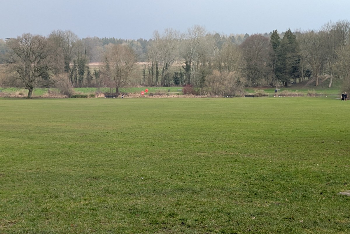
What’s in an image? And indeed what’s in a field? Let’s take it a stage at a time.
The Abbey
The grass in the foreground is part of one of Cirencester’s public parks, the Abbey Grounds. As the name suggests, this is part of the medieval abbey; the abbey buildings and the great abbey church are out of sight behind you in this view. All of those abbey remains are invisible, remaining as only foundations. After the dissolution of the abbeys by Henry VIII, the stonework was pulled down and re-used as building material as the town developed.
You are looking north-east. The first thing you can see beyond the grassed area is a stretch of water. This was dug by the monks to widen and deepen a branch of the River Churn to form a lake to supply fish. You will need to expand the image to see it clearly, it’s marked by benches, life buoys and low vegetation. The two figures in the extreme right are a good guide, they are just our side of the lake.
Abbey House
Also behind us in this view stood Abbey House, demolished in the 1960s. The Abbey land was later owned by the Chester-Master family who built the house, and the park was their private garden. There is one remaining structure from that time in the photo; the large mound at the extreme right covers the ice house built and used by the Chester-Masters.
The Romans
Cirencester is the site of Britain’s second city in Roman times – Corinium, or to give it its full name, Corinium Dobunnorum. The row of trees beyond the lake is close to the Roman city wall. Roman stone was also robbed to build structures in the later town, but out of site to the right of the ice house is a substantial bank and underlying that, the remaining Roman masonry. Some of it has been excavated and remains visible today. If you are visiting the town it’s well worth a look.
While we’re thinking of the Romans, the Abbey Grounds lie entirely within the Roman city and there’s almost certainly more to be discovered here. Just beyond the row of trees mentioned above is another branch of the River Churn. This, and the city wall would together have formed a barrier sufficient to force all traffic in and out of the city through the five large city gates.
Tar Barrow Field
The rising land beyond the line of trees up to the woodland along the sky line is known locally as Tar Barrow Field. ‘Tar’ is probably a corruption of ‘Thor’. The barrows would have been Neolithic or possibly Saxon, but the Medieval inhabitants clearly thought the Norse god Thor was involved in some way. There was also a Roman temple in this field and that would have been reached by a road or footpath from the Roman gate over what is today London Road.
Take a look yourself
If you are visiting Cirencester and interested in the town’s background and history, consider visiting the Corinium Museum (linked below). In addition to checking out the museum itself, you can pick up leaflets about historical sites to visit around the town.
See also:
- Abbey House – Wikipedia
- Cirencester Abbey – Wikipedia
- Corinium Dobunnorum – Wikipedia
- History of Cirencester – Cirencester Town Council
- Welcome to Corinium Museum – Museum website
< Previous | Index | Next >
Useful? Interesting?
If you enjoyed this or found it useful, please like, comment, and share below. (If you don’t see those links, click the article’s title above the main photo and they will appear.) Send a link to friends who might enjoy the article or benefit from it – Thanks! My material is free to reuse (see conditions), but a coffee is always welcome and encourages me to write more often! ![]()

